About the Project
Why?
The road and rail transport infrastructures, being subject to continuous wear and tear, require constant monitoring of their condition. The presence of failures can result not only in economic losses, due to the disruption of essential services for the economy, such as the transportation of goods and people, but also in risks to people and goods.
In Portugal, the road transport network covers 14,332 km [Infraestruturas de Portugal], while the railway network spans 3,600 km [Infraestruturas de Portugal]. Given the scale of these infrastructures, monitoring through visual inspections becomes a slow and costly process. As a result, operators tend to install sensors only at specific points with higher geotechnical risk, such as slopes, retaining walls, bridges, viaducts, and other critical areas, while the rest of the network is monitored through periodic visual inspections. Additionally, conventional geotechnical instrumentation comes at a high cost, with an estimated average installation cost of sensors across the entire network of around €2,500 per kilometre.
In this context, the WISE project aims at finding a solution that:
- Expands the monitored area;
- Reduces the cost of sensing equipment;
- Decreases the need for human intervention;
- Improves the capability for timely and automated failure prediction.
How?
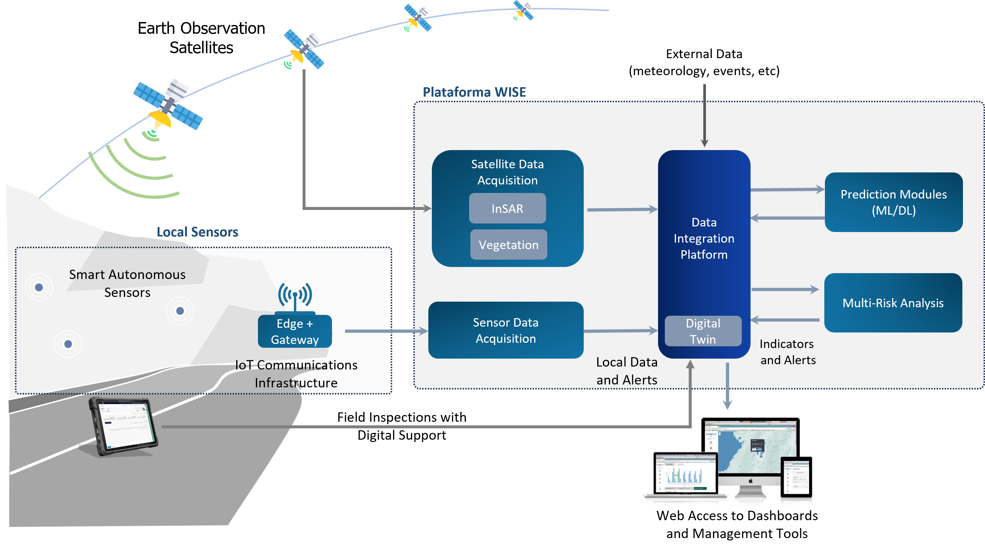
Within the WISE project, a central platform will be develop to integrate various sources of relevant information for monitoring critical infrastructures, allowing it to:
- Be accessed from anywhere through a web interface, providing intuitive dashboards tailored to each monitoring scenario;
- Be processed using modern Artificial Intelligence techniques to anticipate potential threats, reducing the need for human intervention, both locally and remotely.
To achieve this, the project is based on the following key vectors:
- Processing images obtained from Earth observation satellites;
- Developing low-cost sensors to enable local monitoring of relevant data for each monitored scenario;
- Utilizing LoRa/LoRaWAN technology for collecting local monitoring data, allowing for long-range coverage with a fast deployment infrastructure and relatively low costs;
- Developing Artificial Intelligence models using techniques such as Machine Learning and Deep Learning, as well as implementing Digital Twins, which simultaneously leverage multiple available data sources.
By developing an integrated and powerful tool that generates alerts and provides prioritized preventive/corrective recommendations, it becomes possible to anticipate potential threats, contributing to smarter maintenance and security management of critical assets.
Innovation
Regarding the market, the WISE project stands out by overcoming the limitations of other existing solutions, which typically offer a limited database, lack predictive capabilities, and do not integrate with operators' management platforms.
Thus, the WISE project proposes a networked monitoring system for geotechnical assets, leading to reduced risks and lower maintenance costs through the development of an all-in-one web platform for optimal monitoring, intelligent diagnostics, and efficient cost management of critical infrastructures. The project is divided into two main areas: the Local Sensing Infrastructure and the WISE Platform.